1949 Atlanta Aerial Mosaic Project Reveals Built Environment Change
It is no secret that Atlanta’s built environment is in a state of near constant change and anyone familiar with Atlanta will most likely note the apparent lack of “old buildings.” While “old buildings” may be an ill-defined term, when speaking of the lack of old buildings in Atlanta, this can generally be understood as a comment on buildings constructed before the 1930s – meaning structures built before Atlanta and the rest of the country started reconfiguring the built environment to accommodate the automobile. Atlanta certainly has pre-1930s buildings, but many, perhaps too many, have been lost to new development, parking garages, and surface level parking lots. Contrary to popular belief, much of the City of Atlanta existed before the automobile became the dominant mode of transportation. However, beginning in the 1950s the automobile-centered development and redevelopment mentality began to reconfigure the City of Atlanta. Watch this 1956 video, The Dynamic American City, for a better understanding of this national mindset.
In an experimental project, the Georgia State University Library recently created an interactive overlay that reveals the built environment of Atlanta in 1949 from an aerial perspective, just as the city was transitioning from a streetcar city to an automobile-centered city. Created from a collection of 124 aerial photographs from 1949 of the Atlanta area, this aerial mosaic project can be viewed in both Google Maps and Google Earth as a single, unified overlay. Changing the transparency of the 1949 aerial mosaic often reveals significant change. Below are some examples of the loss of old buildings, redevelopment for the automobile, and some other interesting built environment change. In each example the first image is from 1949 and the second image is the most recent Google satellite image and both images represent the exact same geographic area. Since the mosaic overlay is a composite of 124 individual aerial photographs, some areas are lighter than others.
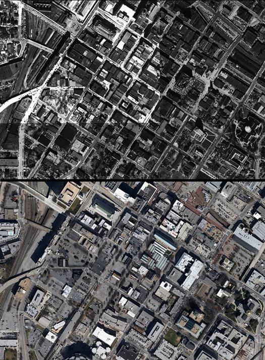 South Downtown – once home to many businesses and “old buildings”, the area is now dotted with many surface level parking lots.
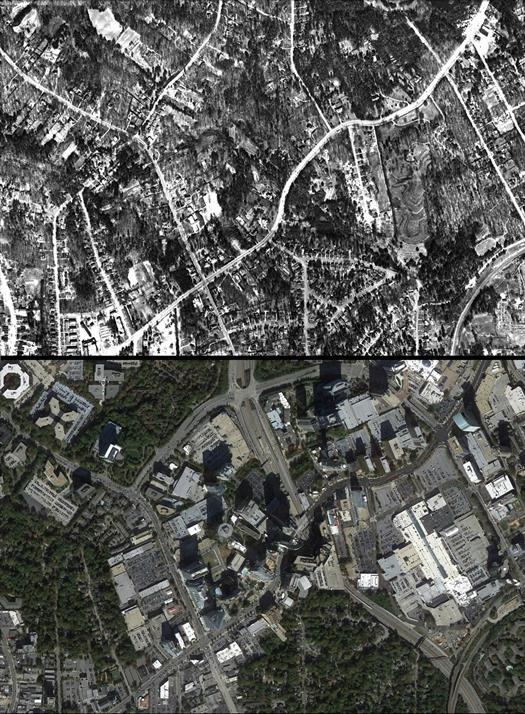 Buckhead – while South Downtown lost many of its “walking/streetcar city” era buildings and much of its density, Buckhead developed into a fairly dense urban center, although not necessarily a pedestrian-oriented urban center.
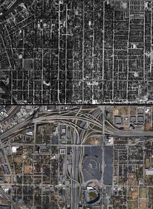 Mechanicsville and Summerhill – in terms of reconfiguring land use, these neighborhoods have arguably seen the most dramatic changes to Atlanta’s built environment.
 Rockdale Park – an entire neighborhood completely eliminated. Once a black residential neighborhood near the Bellwood Quarry (as seen in this map), Rockdale Park met its demise during the city’s urban renewal period. The only building remaining from this neighborhood is the former Rockdale Elementary School (the black, upside-down, T shaped building in the 1949 image). The southern half of the neighborhood is now slated to be part of the future Westside Reservoir Park.
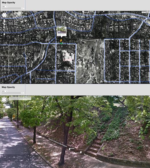 Candler Park – the 1949 aerial overlay reveals where many of Atlanta’s “stairs to nowhere” once led. These stairs along North Avenue that now lead to the Stone Mountain Trail, once led to a single family home.
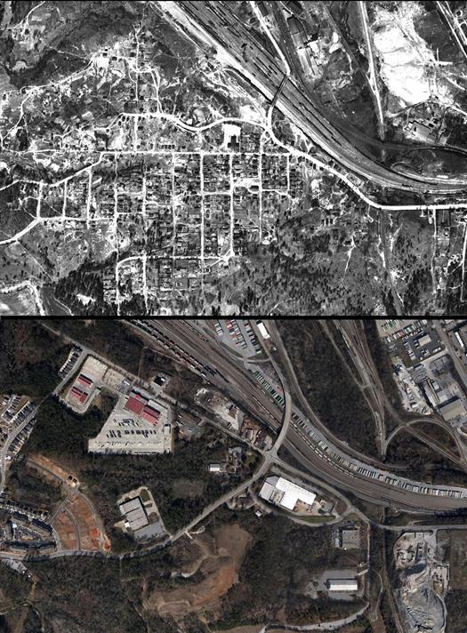
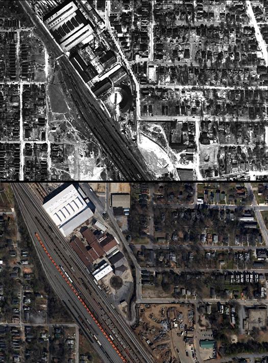 Pittsburgh and Mechanicsville – roundhouses were once common features of railroad towns. Most of Atlanta’s roundhouses are now gone, but the remnants of some still remain.
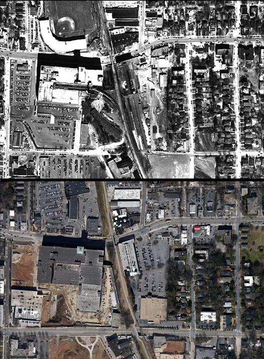 Beltline and Ponce City Market – the 1949 aerial mosaic shows a train entering the Sears Roebuck building, now the Ponce City Market.
The 1949 aerial mosaic overlay is an excellent record of Atlanta’s past built environment. The 1949 aerial photographs were originally digitized and made available online in 2001. With funding from the Georgia State University Library Innovation Fund, this early digitization project was updated by georeferencing each photograph and then stitching all 124 photographs together into a single mosaic overlay. The overlays were created using ArcMap and the open source version of MapTiler. This project is part of a larger digital project, Planning Atlanta: A New City in the Making, 1930s – 1990s.
Please note that the aerial mosaic project was an experiment and while we are very pleased with the final product, there were some issues with the Google Maps overlay. When viewing the mosaic overlay in Google Maps, as you zoom very close to the Earth’s surface, some bit/pixel transparency will occur, meaning that you will see some small pixels or square “holes” in the layer. Unfortunately, the software incorrectly interpreted some of the Google Maps mosaic layer information as having “no data” and, therefore, made some pixels transparent. This issue occurs only with the Google Maps mosaic overlay. To view the entire mosaic overlay without the transparent pixel issues, download the Google Earth mosaic overlay. Alternatively, the individual aerial photographs can be viewed in Google Maps without the transparent pixel issues. Enough technical stuff – go and explore 1949 Atlanta!