Snow Jam 2014: Planning Atlanta, Ryan Gravel, and a Car-Dependent Region

![]() Photo Credit: William Brawley
Photo Credit: William Brawley
Few people can honestly deny that last week’s snow storm in Atlanta was a metropolitan-wide utter calamity. Reflecting on the event that quickly became known as “Snow Jam 2014”, Ryan Gravel, Atlanta Beltline visionary, posed the question, “isn’t this exactly what we wanted?” Referencing metropolitan Atlanta’s lack of transit options, Gravel answers his own question by noting: “We built a car-dependent region because that’s what we wanted, and what happened on Tuesday simply underscores the inherent consequences of that decision.” Acknowledging that it could have been much worse if we had two feet of snow or a chemical spill, Gravel asked, “What if we had to go for weeks without driving? The distances that most people live from where they need to go, and the disconnected nature of our roadway network, would leave most of the region stranded.”
Gravel’s blog post speaks volumes to the consequences of a region that has been obsessed with highway building for the better part of 60 plus years. Highways and a disconnected road network have not always been part of Atlanta. This new type of development largely began in the 1940s and 1950s as county and city officials pushed for an expansive highway network and for creating neighborhood streets that discourage through traffic. This type of urban development is clearly articulated in many planning publications from the Georgia State University Library’s Planning Atlanta collection. Below are a few examples.
The 1952 regional plan, Up Ahead, opened with the following statement:
Crowded, congested cities could be on their way out. In their place we could have a new type of city in the future-wide, green, open and well-planned. Its people would be on wheels and wings, moving swiftly and surely from suburb to suburb, from rim to core and back again. …Metropolitan Atlanta, hub of Piedmont America, is a prime example of the New City in the making. (5)
Although the report went on to warn that if proper planning failed to guide the growth of metropolitan Atlanta, the promise of this new city would be destroyed before it was realized, it also clearly supported the development of a low-density, car-oriented region.
Offering neighborhood design guidelines, Up Ahead recommended that “through streets are eliminated to reduce noise and traffic hazards” and provided an illustration of this “idealized neighborhood layout.” (58) Although the plan envisioned that the reduction of connected streets would “relieve the neighborhoods of the hazards and blight of through traffic,” (58) the effect has generally led to significantly heavy traffic on nearby major roads, as they have become the only option for getting from a place of residence to a place of business and vice versa.
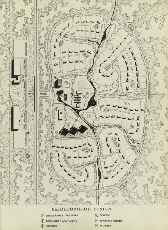 Up Ahead neighborhood design scheme. Note the enclosed residential layout that forces nearly all traffic to the major thoroughfare. (59)
Although Up Ahead was not approved as a regional plan, two years later, in 1954, a new plan, Now for Tomorrow, was approved and became the first metropolitan Atlanta regional plan. Now for Tomorrow also called for similar residential development patterns and provided design plans.
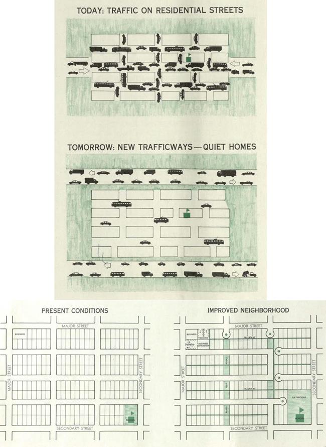 These traffic and neighborhood illustrations in Now for Tomorrow propose redesigning neighborhoods to conform to the limited through traffic concept. (17-18)
While city planners and local officials often supported a car-centric region, they also recognized the dangers of sprawl and by 1957 the Metropolitan Planning Commission (predecessor to ARC) produced a document called Metropolitan Growth Problems, which asked: what will urban development in the Atlanta region look like in 1980: starfish, sprawl, or cluster?
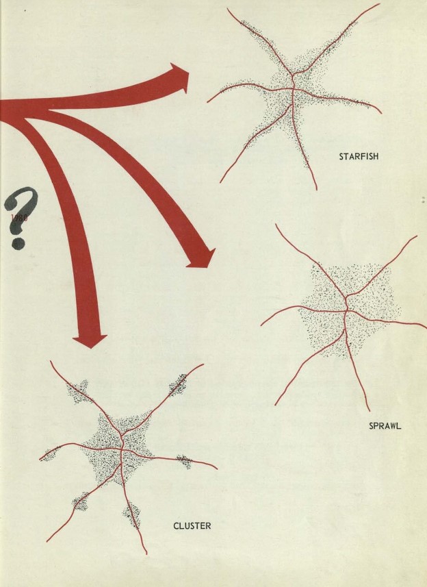 This image from Metropolitan Growth Problems ponders the future urban form of Atlanta in 1980. (ii)
This report stated:
With sprawl development, much public money would go into major connecting thoroughfares instead of rapid transit. The thoroughfares themselves would disperse population so evenly that rapid transit lines could not be efficiently constructed and operated. Many lines would be needed, which would make the cost too great, and many stops would be needed on each line, which would increase travel time too much. Sprawl development implies a heavy — almost exclusive — reliance on private autos instead of public transit, particularly rapid transit… (15)
Referring to cluster development, it reported:
A cluster pattern would be fostered if development were accompanied by — or preceded by — the initiation of high-speed transit service from outlying concentrations into the central district. It would be easier to live 12 miles out, near a rapid transit stop, than it would be to live 3 miles out and fight the traffic every day. (15)
Today, nearly 60 years later, we know all too well the answer to the Atlanta urban form of the future question: as a region, we chose sprawl. And Gravel is correct in noting that we, meaning most people of metropolitan Atlanta, accepted sprawl as the dominant type of urban development. Although a complex myriad of factors influenced Atlanta’s urban form, such as FHA lending policies that encouraged newly constructed single-family home purchases, an interstate highway system that allowed people to easily move to the suburbs, and weak local land use policies that contributed to the loss of an urban fringe, sprawl across the region was, in part, achieved by choosing to live in the many low-density, limited through traffic, suburban neighborhoods that dot the region. The transportation problems associated with sprawl were also realized by voting down the MARTA referendums of the 1960s and 1970s, which would have created a true regional transit system as depicted in this 1961 map:
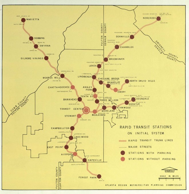 This 1961 transit map shows train line stretching out to Marietta in the northwest and to Forest Park in the south. (Atlanta Region Comprehensive Plan: Rapid Transit, 17)
As a region, we have continued to answer the urban form question posed in 1957 by voting down T-SPLOST in 2012. From the several reports cited in this post, it is clear that transportation has long vexed the Atlanta region. Gravel concluded his post by noting:
But while we may not be able to un-choose the infrastructure system that we built for ourselves over the last sixty years, we can choose to build a better system to support the next million people that will make Atlanta their home. Let’s at least do that.
One way to start would be to revive the transit system proposed back in 1961.