Moment in GSU History: “Building Jarred,” 1949
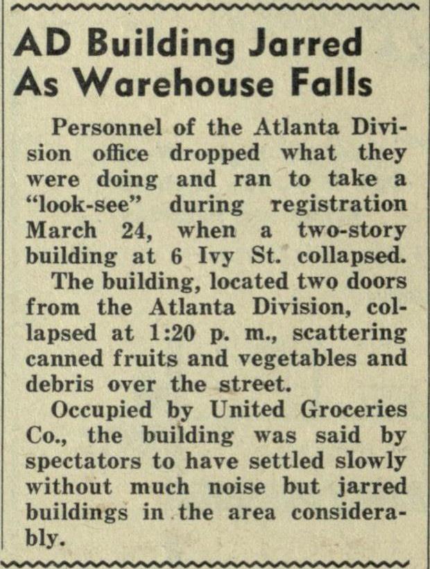
In 1949, the Atlanta Division of the University of Georgia—precursor to Georgia State University—fit all of its students, staff, classrooms and offices into two floors of one building. On the afternoon of March 24th of that year, the whole building, now known as Kell Hall, shook when another structure collapsed just up the block.
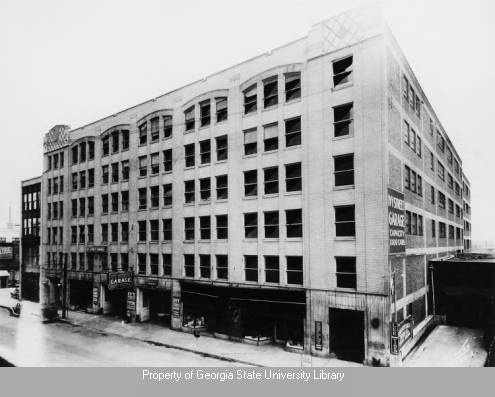
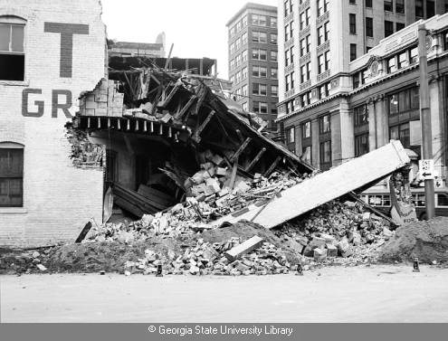
Using resources in the University Library, its Special Collections and Archives, and its Digital Collections, we can learn a surprising amount about the incident and about GSU in those days. Dr. Merl Reed’s Educating the Urban New South (2009) explains how the school obtained the building at 24 Ivy Street, S.E. (later Peachtree Center) and occupied it in 1946, renting the other 4 floors to tenants. According to a 1948-1949 Atlanta city directory, other occupants of the Bolling Jones Building (as it was called until 1964) included the Board of Regents as well as the archives department of Southern Bell Telephone and a cotton brokerage’s “sample rooms.” The building that collapsed contained the United Wholesale Grocery Company. The directories confirm newspaper accounts that the structure was built as a corner gas station, whose overhanging second floor fell during excavation on the street.
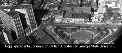
The University Signal’s coverage of the event is in the Library’s Digital Collections, which also contain highlights from Special Collections and Archives’ extensive photographic collection. The image of the collapse was made on the day it occurred by the Lane Brothers Commercial Photographers company, commissioned by a law firm that was involved in the subsequent suit over the damage. Comparing it with a GSU Archives image of the Bolling Jones Building and a 1946 aerial view from the Atlanta Journal-Constitution Photographic Archive, also in the Digital Collections, makes clear how close this catastrophe was to the University’s home. Detailed information about the lots in the area is also available on the Sanborn maps for Atlanta (which show that, by 1952, a parking lot was at 6 Ivy Street).
Both GSU and Atlanta have grown significantly since 1949, when the university’s facilities consisted of two floors in an office building near a grocery warehouse. Today, the Arts & Humanities Building stands on the site of the collapse.
For more on GSU history, consult Merl Reed, Educating the New Urban South: Atlanta and the Rise of Georgia State University, 1913-1969 (Macon, Ga.: Mercer University Press, 2009) and the GSU Archives’ University History Research Guide. The project to digitize the GSU Signal is ongoing, and issues from 1931 into the late 1970s are now online.![]()