“Planning Atlanta” shows Past Illustrations of Future Redevelopment!
There are many hidden gems in GSU’s new “Planning Atlanta”digital collection of historic
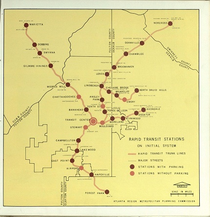
maps and publications tracing Atlanta’s urban evolution over the past 60 years. Particularly poignant are the rapid transit plans put forth by the Atlanta Region Metropolitan Planning Commission in June 1961 in their Atlanta Region Comprehensive Plan: Rapid Transit. In this publication are numerous early MARTA maps that far exceed our current transit options, reaching up to Norcross and Marietta, and even extending a transit line to Emory University. In the face of our current traffic woes, it’s painful to see these early plans were never realized.
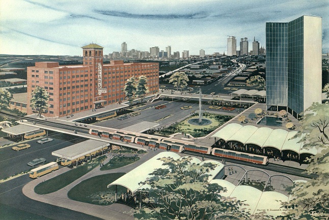
Rapid Transit also visualizes how a transit station would have tied in with the Sears-Roebuck building on Ponce de Leon, complete with pedestrian bridges, high-rise apartments, bus stations and green space. Currently, this building is being redeveloped into a modern version of this mixed-use plan as Ponce City Market which ties in with the Atlanta Beltline. When funding is secured, one day light rail will move past Ponce City Market, connecting neighborhoods and relieving street congestion, just as pictured in this 1961 illustration.
The Atlanta Beltline is officially opening its Eastside Trail on Monday October 15th which stretches from Piedmont Park, past Ponce City Market and into the Old Fourth Ward and Inman Park. Check out Rapid Transit to see illustrations of the Beltline before it was the Beltline, along with an aerial photograph of the baseball field that became Midtown Place Shopping Center, and other interesting transit data!